Beidou helping Tajikistan prep for temblors
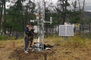
China DailyA monitoring tower on the bank of the lake collects data on deformations on the dam. Along with providing stable navigation services worldwide, the Beidou global satellite navigation system developed by China has been monitoring the deformation of Lake Sarez in the seismically active zone of the Pamir Plateau in eastern Tajikistan for nearly three years, predicting potential earthquakes. The monitoring system started operating in October 2021, and since its expansion the following year, the Beidou monitoring network at Sarez has been consistently monitoring millimeter-level deformations on the dam and providing data. In 2021, the CAS Research Center of Ecology and Environment of Central Asia organized a joint effort with the CAS National Time Service Center and the CAS Xinjiang Institute of Ecology and Geography to bring domestic technology and analytical methods to Tajikistan. In early April 2021, the CAS Research Center of Ecology and Environment of Central Asia organized a technical team to construct a simulation system and conduct tests at the Fukang Desert Ecosystem National Field Scientific Observation and Research Station in the Xinjiang Uygur autonomous region.
